South Wairarapa District Speed Changes 2026
Overview and upcoming speed limit changes
South Wairarapa District Council is implementing speed limit changes progressively across the district this year following the approval of the Speed Management Plan (the Plan) by the Director of Land Transport in November 2025.
The Plan is designed to improve road safety across the district, with a particular focus on roads where there is a higher potential safety risk.
Approach and key focus areas
The Council’s approach prioritises speed management in locations where reduced speeds are expected to make the greatest safety impact. These include:
- Areas around schools and marae
- High-risk routes where lower speed limits are considered appropriate
- Peri-urban roads with high levels of walking and cycling activity
- Coastal settlement roads with residential use and limited footpaths
- Unsealed roads, which make up approximately 30% of the district’s roading network
Read the approved Speed Management Plan here
Progress to date
The first phase of The Plan was implemented in January 2026 with variable speeds before and after school bell times, supported by new signage, to better protect students and families during busy pick-up and drop-off periods. These measures reflect the Council’s priority to improve safety for children and families.
The next step in the phased lower speed changes was to Martinborough’s peri-urban roads in March, which was followed with lower speed changes to peri-urban roads in both Featherston and Greytown in April.
The last stage in the implementation of lower speeds is on rural roads across the district. Work on lower speed implementation on these roads is outlined below. It will begin in the last week in April and is anticipated to take several weeks to complete.
Upcoming speed limit changes and implementation
Rural roads – scheduled for April-May 2026
Lower speed limits will be implemented on rural roads across South Wairarapa from late April through to May. New signage supports the changes. Full details are laid out in the chart below.
These new lower speed limits impact rural roads from the east and south coasts to rural zones around Featherston and Greytown:
Most of the new lower speed limits are to unsealed roads and see a reduction from 100 km/h to 80 km/h. There are a few areas, such as mountainous Cape Palliser Road and Western Lake Road, which reduce to 60km/h and areas of Lake Ferry and Ngawi, which reduce to 40km/h to account for residential areas with no footpaths.
Rural roads are the final tranche to have lower speed limits implemented in 2026 from the Speed Management Plan.
| Road (including the start and end locations) | Existing speed limit (km/h) | New speed limit (km/h) |
| Lake Ferry Road between 2.34km southwest of Cape Palliser Road and 2.48km southwest of Cape Palliser Road (at existing 100/50 km/h speed limit change) | 100 | 40 |
| Lake Ferry Road between 2.48km southwest of Cape Palliser Road (at existing 100/50 km/h speed limit change) and the end of Lake Ferry Road | 50 | 40 |
| Whangaimoana Beach Road | 100 | 60 |
| Cape Palliser Road between 5.51km south of Whangaimoana Beach Road and 0.1km south of Te Miha Crescent | 100 | 60 |
| Cape Palliser Road between 250m northwest of Tilson Avenue (at the existing 100/50 km/h speed limit change at Ngawi) and 105m south of Seaview Avenue (at the existing 50/100 km/h speed limit change at Ngawi) | 50 | 40 |
| Te Miha Crescent | 100 | 40 |
| Tilson Avenue | 50 | 40 |
| Hemi Street | 50 | 40 |
| Seaview Avenue | 50 | 40 |
| Cape Palliser Road between 450m north of Mangatoetoe Grove and the end of Cape Palliser Road | 100 | 60 |
| Ben Avon Grove | 100 | 40 |
| Mangatoetoe Grove | 100 | 40 |
| Western Lake Road from 6.46km South of Cross Creek Road to 8.47km Northwest of East West Access Road | 100 | 60 |
| McDougalls Road from Lake Ferry Road to end of road | 100 | 60 |
| Ahikouka Road from 1140 metres south of State Highway 2 to end of road | 100 | 80 |
| Backwater Road from 20 metres south of State Highway 53 to end of road | 100 | 80 |
| Backwater Road East from Backwater Road to end of Road | 100 | 80 |
| Bartons Road from 40 metres southwest of Western Lake Road to end of Road | 100 | 80 |
| Beach Road from 30m southeast of Western Lake Road to the beach | 100 | 80 |
| Bicknells Road from 30m of Kahutara Road to end of road | 100 | 80 |
| Birch Hill Road from 30 metres northwest of White Rock Road to end of Road | 100 | 80 |
| Blue Rock Road from Dry River Road to Ruakokoputuna Road | 100 | 80 |
| Buicks Road from 220 metres south of Pahautua Road to end of Road | 100 | 80 |
| Bush Gully Road from Moeraki Road to Pahaoa Road | 100 | 80 |
| Cannock Road from 60 metres southeast of Hinekura Road to end of road | 100 | 80 |
| Cape River Road from White Rock Road to end of road | 100 | 80 |
| Chishams Rd from Lake Ferry Road to end of road | 100 | 80 |
| Clarkes Road from 20 metres southwest of Kahutara Road to end of road | 100 | 80 |
| Clay Creek Road from Haurangi Road to end of road | 100 | 80 |
| Cross Creek Road from 20 metres northwest of Western Lake Road to end of road | 100 | 80 |
| Donalds Road from Ashbys Line to end of Road | 100 | 80 |
| Dry River Road from 8420 metres south of Lake Ferry Road to Blue Rock Road | 100 | 80 |
| Duddings Line from 40 metres east of No 1 Line to Phillips Line | 100 | 80 |
| Fenwicks Line from Phillips Line to Wards Line | 100 | 80 |
| Georges Road from 370 metres southwest ofState Highway 53 to end of Road | 100 | 80 |
| Glendhu Road from Pahaoa Road to end of Road | 100 | 80 |
| Glendryneoch Road from Pahaoa Road to end of Road | 100 | 80 |
| Glenmorven Road from 70 metres southeast of Bidwills Cutting Road to end of Road | 100 | 80 |
| Greens Road from 20 metres north of State Highway 2 to end of Road | 100 | 80 |
| Woodside Road from 3770 metres west of Humphries Street to Waiohine Valley Road | 100 | 80 |
| Harris Road North from White Rock Road to end of Road | 100 | 80 |
| Haurangi Road from Ruakokopatuna Road to Clay Creek Road | 100 | 80 |
| Haurangi Road from Clay Creek Road to end of Road | 100 | 80 |
| Hecklers Road from 40m metres south of Papawai Road to end of Road | 100 | 80 |
| Hikawera Road from 20 metres nort of Hinekura Road to end of Road | 100 | 80 |
| Hikunui Road from 1540 metres northeast of Pahautea Road to end of Road | 100 | 80 |
| Hinekura Road from 1520 metres northwest of Moeraki Road to Moeraki Road | 100 | 80 |
| Hodders Road from 20 metres west to Murphys Line to end of Road | 100 | 80 |
| Humes Road from Yeronga Road to end of Road | 100 | 80 |
| Judds Road from 40 metres northwest of Kahutara Road to end of Road | 100 | 80 |
| Kaiwaka Road from White Rock Road to end of Road | 100 | 80 |
| Kemptons Line from 1550metres southeast of Bidwills Cutting Road to 30metres southwest of Fabians Road | 100 | 80 |
| Kumenga Road from 20 metres northwest of East West Access to end of road | 100 | 80 |
| Lagoon Hill Road from 60 metres east of White Rock Road to end of Road | 100 | 80 |
| Longwood Road West from 20 metres west of Murphys Line to North Soldiers Settlement Road | 100 | 80 |
| Mahaki Road from 40 metres north of Lake Ferry Road to end of Road | 100 | 80 |
| Maramamau Road from 40 metres southwest of Kahutara Road to end of Road | 100 | 80 |
| Moeraki Road from Hinekura Road to Ngakonui Road | 100 | 80 |
| Moiki Road from 500 metres South of Bidwills Cutting Road to end of Road | 100 | 80 |
| Moroa Road from 60 metres east of No 1 Line to 50 metres west of Battersea Road | 100 | 80 |
| Ngakonui Road from Moeraki Road to Wainuioru Road | 100 | 80 |
| Ngapotiki Road from White Rock Road to end of Road | 100 | 80 |
| North Soldiers Settlement Road from Longwood West Road to Viles Road | 100 | 80 |
| Ocean Beach Road from Wharekauhau Road to end of road | 100 | 80 |
| Oystershell Road from 30 metres north of Hinekura Road to end of Road | 100 | 80 |
| Pahaoa Road from Bush Gully Road to end of Road | 100 | 80 |
| Papatahi Road from 40 metres northwest of East West Access Road to end of Road | 100 | 80 |
| Parera Road from 40 metres northwest of Kahutara Road to end of Road | 100 | 80 |
| Paruwai Road from Range Road to end of Road | 100 | 80 |
| Pharazyns Road from Phillips Line to end of Road | 100 | 80 |
| Phillips Line from 20 west of Battersea Road to 50 metres north of State Highway 53 | 100 | 80 |
| Pouawha Road from 60 metres north of Lake Ferry Road to end of Road | 100 | 80 |
| Pukio East Road from 40 metres northwest of Lake Ferry Road to end of Road | 100 | 80 |
| Pukio West Road from 250 metres south of Kahutara Road to 520 metres northwest of Pahautea Road | 100 | 80 |
| Raho Ruru Road from 40 metres west of Lake Ferry Road to end of Road | 100 | 80 |
| Range Road from 40 metres west of White Rock Road to Puruwai Road | 100 | 80 |
| Riverside Road from 30 metres north of Ponatahi Road to end of Road | 100 | 80 |
| Ruakokoputuna Road from 30 metres south of White Rock Road to Haurangi No 1 Road | 100 | 80 |
| Settlement Road from 20 metres northwest of Battersea Road to end of Road | 100 | 80 |
| Southdown Drive from Sutherland Drive to end of Road | 100 | 80 |
| Summerhill Road from Wainuioru Road to end of Road | 100 | 80 |
| Sutherland Drive from 50 metres South of Fraters Road to end of Road | 100 | 80 |
| Tauherenikau Diversion Road from 50 metres southwest of Kahutara Road to end of Road | 100 | 80 |
| Te Awaiti Road from Tora Road to end of Road | 100 | 80 |
| Te Hopai Road from 30 metres northwest of East West Access Road to end of Road | 100 | 80 |
| Te Muna Road from 1910 metres northeast of White Rock Road to 30 metres northeast of White Rock Road | 100 | 80 |
| Te Rata Road from Whakatomotomo Road to end of Road | 100 | 80 |
| Tilsons Road from 30 meters east of Papawai Road to end of Road | 100 | 80 |
| Tora Farm Settlement Road from Tora Road to end of Road | 100 | 80 |
| Tora Road from 4150 metres southeast of White Rock Road to Te Awaiti Road | 100 | 80 |
| Underhill Road from Woodside Road to end of Road | 100 | 80 |
| Warrens Road from 30 metres northwest of Lake Ferry Road to end of Road | 100 | 80 |
| Wainuioru Road from Clifton Grove Road to Summerhill Road | 100 | 80 |
| Waiohine Valley Road from Woodside Road to end of Road | 100 | 80 |
| Wairio Road from 30 metres northwest of Kahutara Road to end of Road | 100 | 80 |
| Whakarua Road from 80 metres east of Longbush Road to end of Road | 100 | 80 |
| Whakatomotomo Road from 50 metres southeast of Lake Ferry Road to end of road | 100 | 80 |
| Wharekauhau Road from Ocean Beach Road to end of Road | 100 | 80 |
| Whareroto Road from 30 meters north wst of Kahutara Road to end of Road | 100 | 80 |
| White Rock Road from 50 metres southeast to Tora Road to Ngapotiki Road | 100 | 80 |
| Yeronga Road from 30 metres east of Lake Ferry Road to end of road | 100 | 80 |
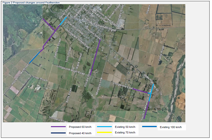
Completed and implemented in April 2026 – Featherston peri-urban roads
| Road (Include the start and end locations) | Existing speed limit (km/h) | New speed limit (km/h) |
| Cundys Road | 100 | 60 |
| Donald Street between SH53 and Longwood West Road | 100 | 60 |
| Western Lake Road from 100m southwest of Moore Street (at existing 50/100km/h speed limit change) to 200m south of railway crossing | 100 | 60 |
| Longwood East Road between 550m west of South Featherston Road and 50m west of South Featherston Road (at the existing 100/50 km/h speed limit change) | 100 | 60 |
| South Featherston Road between 400m south of Longwood East Road and 1000m south of Longwood East Road (700m south of the existing 100/50 km/h speed limit change) | 100 | 60 |
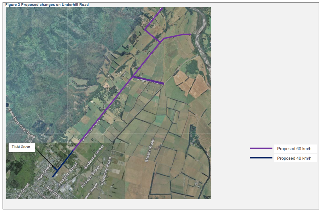
| Underhill Road between Harrison Street West and the existing 50/100 km/h speed limit change | 50 | 40 |
| Titoki Grove | 50 | 40 |
| Underhill Road between existing 50/100 speed limit change and end of road | 100 | 60 |
| Bucks Road | 100 | 60 |
| Algies Road | 100 | 60 |
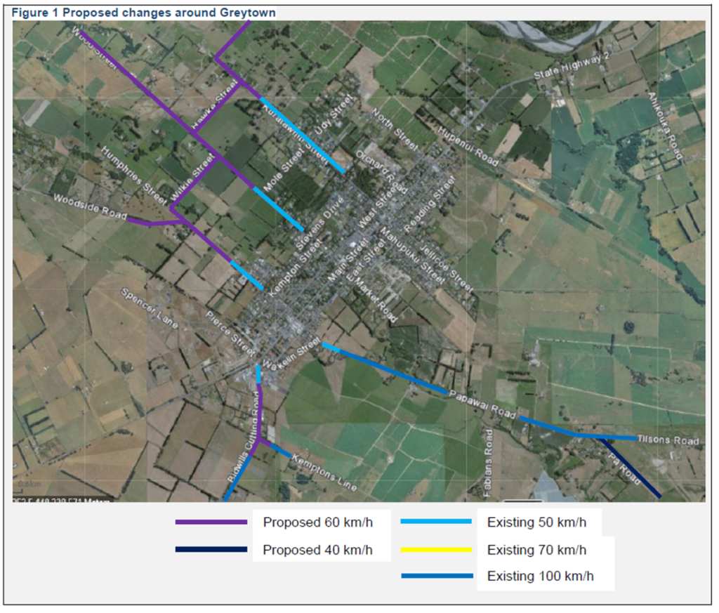
Completed and implemented in April 2026 – Greytown peri-urban roads
| Road (Include the start and end locations) | Existing speed limit (km/h) | New speed limit (km/h) |
| Hawke Street between Kuratawhiti Street and Wood Street | 100 | 60 |
| Kuratawhiti Street between 185m southeast of Hawke Street (at the existing 50/100 limit change) to the end of Kuratawhiti Street at Waiohine River. | 100 | 60 |
| Wilkie Street between Humphries Street and Wood Street | 100 | 60 |
| Humphries Street between Wilkie Street and existing 100/50 km/h speed limit change of Humphries Street | 100 | 60 |
| Greytown-Woodside Road between Humphries Street Road and 350m north of Humphries Street | 100 | 60 |
| Wood Street between 125m northwest of Mole Street (at the existing 50/100 km/h speed limit change) and the end of Wood Street | 100 | 60 |
| 70 zone in Bidwills Cutting Road | 70 | 60 |
| Pā Road | 50 | 40 |
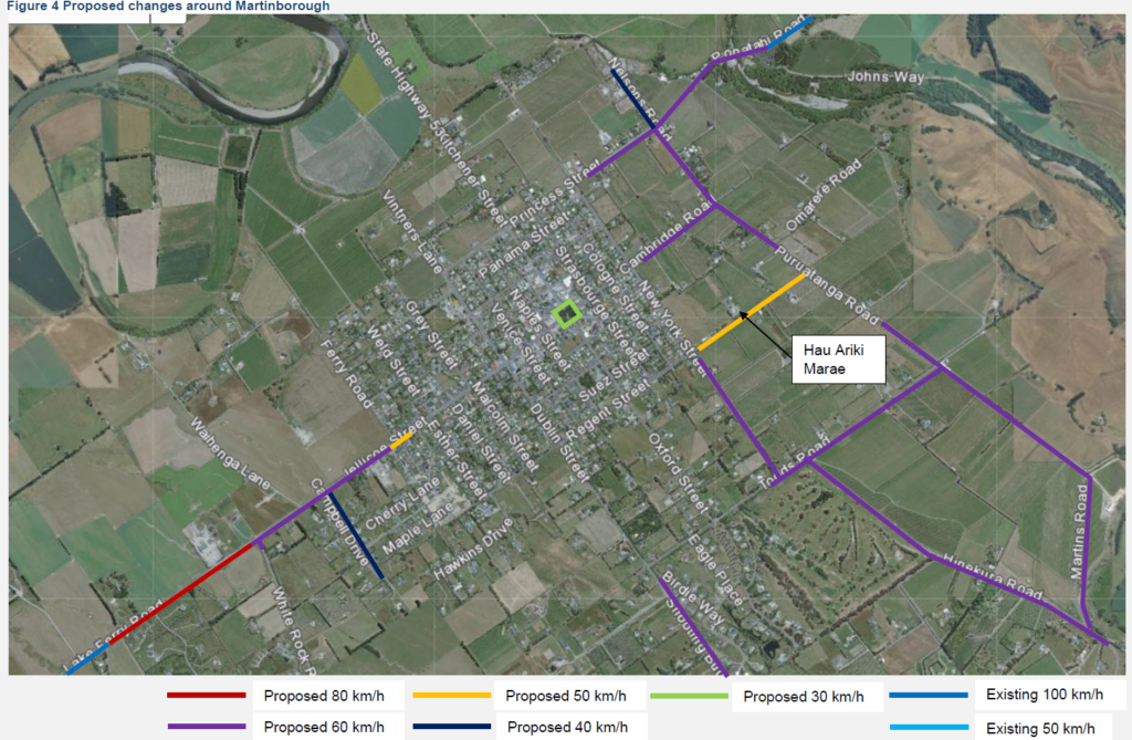
Completed and implemented in March 2026 – Martinborough peri-urban roads
Princess Street, Martinborough
(between New York Street and Nelsons Road)
Speed reduction from 70km/h to 60km/h, changes on 26 March
Ponatahi Road, Martinborough
(between Nelsons Road and Johns Way across Huangarua Bridge)
Speed reduction from 100km/h to 60km/h, changes on 26 March
White Rock Road, Martinborough
(between Lake Ferry Road and 50km south of Lake Ferry Road)
Speed reduction from 100km/h to 60km/h, changes on 1 April
Memorial Square, Martinborough
Speed reduction from 50km/h to 30km/h, changes on 1 April
Nelson Road, Martinborough
Speed reduction from 70km/h to 40km/h, changes on 1 April
Martins Road, Martinborough
(Between Hinekura Road and Puruatangi Road)
Speed reduction from 100km/h to 60km/h, changes on 1 April
Cambridge Road, Martinborough
(between 50m north east of New York Street and Puruatanga Road)
Speed reduction from 70km/h to 60km/h, changes on 1 April
Puruatanga Road, Martinborough
(from Cambridge Road to 35m northeast of Regent Street)
Speed reduction from 70km/h to 60km/h, changes on 1 April
Puruatanga Road, Martinborough
(between 35m northeast of Regent Street and Martins Road)
Speed reduction from 100km/h to 60km/h, changes on 1 April
Hinekura Road, Martinborough
(between 50m south of Martins Road and Todds Road)
Speed reduction from 100km/h to 60km/h, changes on 1 April
Todds Road, Martinborough
(between Puruatanga Road and 100m west of New York Street)
Speed reduction from 100km/h to 60km/h, changes on 1 April
New York Street, Martinborough
(between Todds Road and 50m south of Regent Street)
Speed reduction from 100km/h to 60km/h, changes on 1 April
Shooting Butts Road, Martinborough
(between 50m south of Todds Road and 50m east White Rock Road)
Speed reduction from 100km/h to 60km/h, changes on 1 April
Regent Street, Martinborough
(from 100m northeast of New York Street to Puruatanga Road)
Speed reduction from 100km/h to 50km/h, changes on 1 April
Lake Ferry Road, Martinborough
(between 50m southwest of White Rock Road and 850m southwest of White Rock Road)
Speed reduction from 100 to 80km/h, changes on 1 April
Jellicoe Street, Martinborough
(between 90m northeast of Ferry Road and 50m southwest of Ferry Road)
Speed reduction from 70km/h to 50km/h, changes on 1 April
Jellicoe Street, Martinborough
(between 50m southwest of Ferry Road and 75m southwest of Campbell Drive)
Speed reduction from 70km/h to 60km/h, changes on 1 April
Jellicoe Street, Martinborough
(between 75m southwest of Campbell Drive and 50m southwest of White Rock Road)
Speed reduction from 100km/h to 60km/h, changes on 1 April
Campbell Drive, Martinborough
(between Jellicoe Street and end of road)
Speed reduction from 50km/h to 40km/h, changes on 1 April
Huangarua Road, Martinborough
(between Princess Street and Cambridge Road)
Speed reduction from 70km/h to 60km/h, changes on 1 April